IMPERIAL VALLEY GEOTHERMAL DATABASE PACKAGE
Imperial Valley Geothermal Region – Geologic Database Package – $25,000
Contact us at tldavisgeo@gmail.com for purchase agreement and preferred software platform formats and delivery options
Non-distribution contract required
The Imperial Valley Geothermal Database package is designed to save companies the time and expense of having to compile a diverse set of data into one coherent digital database for use with geologic software such as Geographix, Petra, Petrel, and others. It has been compiled by geoscientists with extensive knowledge of the geology of the state of California as well as decades of experience in subsurface geology and modeling for extractive industries. This unique package will allow companies and technical staff to immediately start their own evaluation of the study area, with a quality-checked database providing a comprehensive inventory of publicly available information.
Note: Database does not include information for development projects of resources on federal lands, which, to date, is not publicly available (East Mesa Geothermal Field).
INCLUDES:
Well Database (Well Data)
-
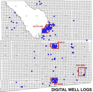
1463 total boreholes (includes redrills & sidetracks of existing wells) within study area of the Imperial Valley of Imperial County. Includes oil & gas exploration wells, geothermal wells, and temperature gradient survey holes.
-
All wells located as per CalGEM or well history records (Lat/Long and Township/Range/Section)
-
All wells classified by purpose (Exploratory Oil/Gas, Exploratory Water, Development Water, Injection, Other Geothermal, Thermal Gradient)
-
Basic well header information (Elevation, Total Depth, Field Name, etc.)
-
Directional surveys – all publicly available deviation data input to database 341 boreholes
-
Dipmeter data – compiled and input to database where available 55 wells
-
Wellbore mechanical data: 630 boreholes
-
Casing sizes and depths
-
Perforated (completion) intervals
-
-
Well logs – well logs completed to date (available for purchase separately) include:
-
Electric Logs: SP, GR, Deep & Shallow Resistivity
-
Gamma/Density: GR, Caliper, Density Porosity, Neutron Porosity, Density Correction
-
Miscellaneous: Temperature (continuous), Sonic Travel Time (dT), Sonic Porosity (SPHI), Photo Electric Factor (PEF)
-
333 boreholes with digital well logs
-
-
Temperature Data 273 boreholes:
-
Compiled from well records and/or logs
-
Temperature readings stored for Below Ground Surface (BGS) depths at 100′, 500-6000′ at 500′ intervals, 1000′ intervals beyond 6000′ BGS.
-
-
Water Chemistry 51 boreholes:
-
Compiled from well records
-
29 Categories stored (pH, TDS, Ions including Li, Zn, B, etc.)
-
-
-
Production/Injection Data: 237 boreholes
-
Compiled from state records (CalGEM) for wells on non-federal lands (ie. excludes East Mesa Geothermal Field)
-
Monthly water production volumes, steam rate, water rate, TDS of produced fluids, Temperature, Pressure
-
Monthly water Injection volumes, water rate, TDS, Temperature, Pressure
-
Map database (Map Data)
-
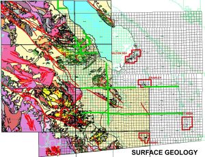
Surface Geology
-
From surface geologic maps by Thomas Dibblee Jr.
-
Quads included: Durmid, Kane Spring, Plaster City/Brawley, Coyote Wells/Heber, Jacumba, Mt Laguna/Carrizo Mtn, Borrego/Borrego Mtn, Clark Lake/Rabbit Peak
-
-
Landgrid
-
Township/range/Sections
-
-
Geothermal Fields
-
Formal Geothermal Field boundaries
-
-
Federal Lands
-
Extents/Coverage of Federal Lands in Study Area
-
-
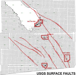
USGS Surface Fault Traces